[Note: I will publish the updated Smoke Rise Trails Map in a separate post and include links to previous articles describing each hike in detail.]
Here is the description of Bear Mountain Trail which has just recently been marked:
Bear Mountain Trail - approximately 2 miles. This trail has been marked with pink ribbons, and will be blazed in the spring. The trail is accessed at the end of Smoke Rise Road. It is a beautiful hike of moderate difficulty that gives scenic overviews of our community.
Note: this trail is closed and not safe to hike from October 1 until February 1, due to hunter activity.
Given the October 1 hunting warning, we talked our friends the Grays into joining us on October 26, 2010 to explore and document for you the Bear Mountain Trail in Kinnelon! Our group consisted of 4 adults and 3 children ranging in age from 5 to 10.
Before setting off, I asked Ken for a few more details. Emma and I had driven by the end of Smoke Rise Road and had found no indication of a trail. We followed Ken's instructions, that once you reach the end of Smoke Rise Road, walk straight and follow the power lines [Note: the power line poles are gargantuan metal poles] that eventually connect to Spice Bush Road.
On your left, after a rock outcropping, you'll notice 2 small foot bridges. Take the second bridge [the first one doesn't seem to go anywhere] and follow the pink ribbons.
The pink-ribbon marked trail rises gently for quite a while with a few switchbacks. We passed a number of other trails going off in other directions which are apparently unmarked [to be further explored]. All the while, our trail gained elevation until we left a pleasant trail of no great difficulty and found ourselves on a fairly difficult trail scrambling over rocks and through scrub and up some fairly steep sections.
We finally reached a long granite ridge almost at the highest elevation after which we could find no further pink ribbons [per Ken, at that point, the trail will need to be blazed on the rocks]. The obvious trail does continue up the ridge rising as it goes until there is a fairly precipitous although perhaps possible descent with no ribbons in site or a further ascent with no clearly marked trail. At that point, we retraced our steps back along the pink-ribbon marked trail.
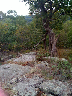
Along the hike, we could hear sounds of a marching band from the Kinnelon High School. At the highest points, we saw the Smoke Rise riding fields and other mountains in the distance [Buck Mountain?]. Had the trees not been so leafy, we expect that we could have seen forever! [See picture above.]
Here are details of our Bear Mountain trail which I started documenting at Long Meadow and Smoke Rise Road. For a number of reasons - not least of which is that I don't fully believe what trail tracker documented [we had to have gone farther than 1.4 miles] - we are eager to set out with Ken Bitz in the spring to fully understand this trail! That will be Part II of Kinnelon's Bear Mountain Trail.
Note: in terms of Kinnelon Critters, we noticed signs of dear and bear.
Bear Mountain Kinnelon NJ
EveryTrail - Find trail maps for California and beyond
In the meantime, if you have any experience with trails along Bear Mountain in Kinnelon, would you let me know? We'd love to find a way to hike to Kinnelon's Borough Hall...
On another note, if you can share perspective on the hunting scene in Kinnelon, I'd appreciate it. I hate having to wait until the Spring to go exploring.
Ted &


No comments:
Post a Comment