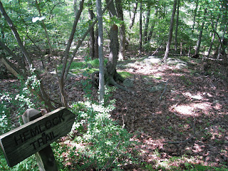
 Last Sunday, Ted and Emma went off for a short hike along the Hemlock Trail in Smoke Rise - allowing me time to put the final touches on my just published e-Book "Social Media's Collective Wisdom: Simplifying Marketing With Social Media".
The Hemlock Trail is described in the Smoke Rise Trails Map as follows:
Hemlock Trail [orange]:
Round Trip walking time: 20 minutes
 Head of trail begins at the intersection of Summit Terrace South and Bush Hill Road. Park on the left shoulder on Summit Terrace South near large glacial erratic on right at trail entrance. Note giant hemlock within first 100 yards on right side of trail [ten foot circumference at the base]. Mini-palisades on the left and beautiful stand of hemlocks throughout. Trails ends at cul-de-sac of Hemlock Lane between #12 and #16 Hemlock Lane.
Entire circuit approx. 1/2 to 3/4 mile.
 Let me clarify up front: they did NOT do the entire trail [I'll share that with you in a separate post].
And, they did NOT start at the glacial erratic.
Instead, they started at the trail end [as described in the Smoke Rise Trails Map] on Hemlock Lane where you will find a trail marker that indicates "Hemlock Trail" [see photo above].
From this direction, the trail takes you through a boggy area made passable via these boards.
WARNING! Proceed very carefully! Many of the boards are moss-covered and slippery. Others are no longer anchored and stable. A misstep may land you - as it did Ted twice - in the bog!

 Once past the bog, you reach the wooded section of the trail, which - in the depth of summer - is green and lush and not necessarily easy to follow.
Ted observed that trail markers were hard to find and follow given leaf coverage. They may also need some refreshing...
Rather than proceed north toward the beginning of the trail [and the erratic], Ted and Emma proceeded south, down the gully and toward Hoot Owl Pond.
Can you glimpse the water through the trees in this next photo? Pretty magical.
Have you taken the Hemlock Trail? What do you love most about it?
Next post, I'll take you through the entire trail. Be warned though: it's a winter scene...

Technorati Tags: Hemlock Trail Smoke Rise Hemlock Trail Smoke Rise Trails Del.icio.us Tags: Hemlock Trail Smoke Rise Hemlock Trail Smoke Rise Trails


No comments:
Post a Comment